These maps give fans, residents, and visitors a clear picture of how North Texas will move during the FIFA World Cup 2026™, showing how stadiums, fan zones, rail lines, charter buses, and walking routes all connect into one coordinated system. They highlight planned road closures, special transit services, and pedestrian‑priority corridors designed to keep people safe, reduce congestion, and make it easy to enjoy matches and events across the region—from downtown Dallas and Fair Park to Dallas Stadium and beyond
PRIMARY LOCATIONS
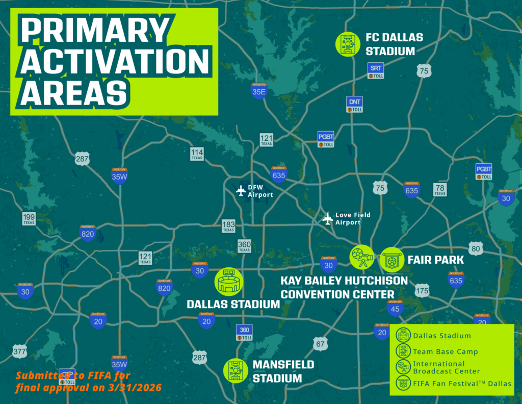
This is a map of the primary activation areas in North Texas for FIFA World Cup 2026™ events. FC Dallas Stadium in Frisco and Mansfield Stadium in Mansfield will serve as base camp locations for teams participating in the tournament. Matches will be held at Dallas Stadium in Arlington. The International Broadcast Center is located at the Kay Bailey Hutchison Convention Center in downtown Dallas, while the FIFA Fan Festival™ Dallas will be held at Fair Park in Dallas.
ROAD CLOSURES
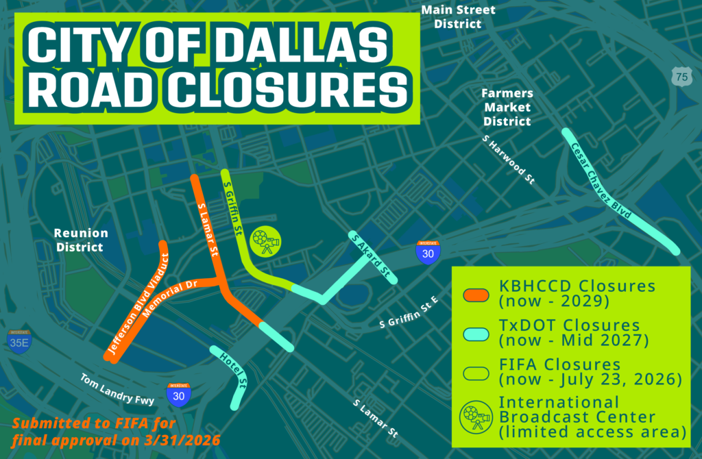
A map of road closures in downtown Dallas near the Kay Bailey Hutchinson Convention Center Dallas, which will be used as the International Broadcast Center for the FIFA World Cup 2026™. To accommodate ongoing construction at the KBHCCD, the following streets have been closed: Lamar Street from Ceremonial on the north to the parking lot access point on the south side, Memorial Drive from Lamar Street to Hotel Street. The Lamar Bridge, Akard Street, and Hotel Street are also closed. FIFA plans to fully close Griffin Street between Canton Street & Ceremonial Drive from May 26 until July 23, 2026.
FIFA FAN FESTIVAL™ DALLAS AT FAIR PARK
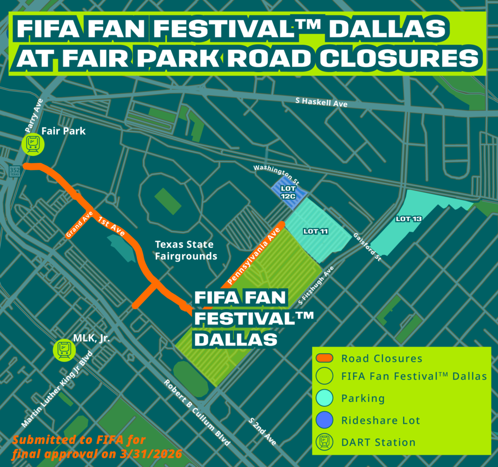
A map of the road closures near the FIFA Fan Festival™ Dallas at Fair Park, with the Fan Festival location, parking, and Rideshare lots clearly marked. The official FIFA Fan Festival™ Dallas will be held at The Pavilion at Fair Park amphitheater, which is outlined in green on the northeast portion of Fair Park. Free parking will be nearby. The Rideshare Lot is located between Washington Street and McKenzie Street. The road closures are highlighted in orange: First Avenue from Parry Avenue to Pennsylvania Avenue, Grand Avenue from First Avenue to Second Avenue, Martin Luther King, Jr. Boulevard from First Avenue to Second Avenue, and Pennsylvania Avenue from First Avenue to Lagow Street. The DART Fair Park Station is located on Parry Avenue, north of First Avenue. The DART MLK Jr. Station is located on South Boulevard near MLK Jr. Boulevard.
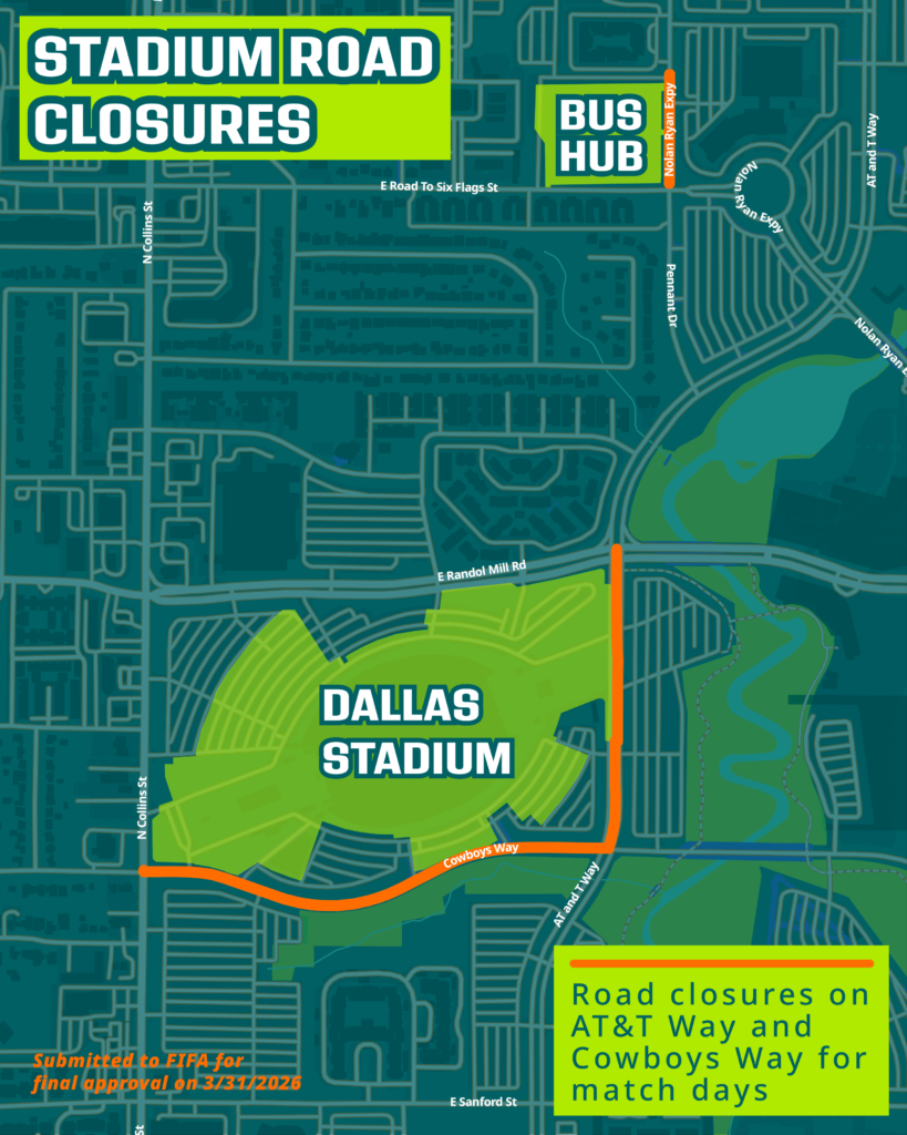
DALLAS STADIUM ROAD CLOSURES
This is a map of the roads that will be closed near Dallas Stadium on match days. AT&T Way will be closed from Cowboys Way to Randol Mill Road. Cowboys Way will be closed from N. Collins Street to AT&T Way. A portion of Nolan Ryan Expy from Road to Six Flags to south entrance of hotel will be closed to accommodate match day operations.
MATCH DAY TRANSIT
This map shows how guests attending the matches can use transit to get to Dallas Stadium. The primary stations for boarding Trinity Railway Express (TRE) commuter rail will be in downtown Dallas at Victory Station (served by the DART Green and Orange Lines) and the Fort Worth Central Station in downtown Fort Worth, which is also a stop for the TEXRail system. At the TRE Centreport Station guests will exit the train, and game day ticket holders will be provided complimentary Charter Buses to the Bus Hub just north of Dallas Stadium where there will be a 10-minute walk to the stadium. Should the train be at capacity and lines are forming, there will be Dynamic Charter Buses available for game day ticket holders available to take patrons to the Stadium as well as from the Victory and Fort Worth Central Stations. A ticket will be needed to ride the TRE. Everyone is encouraged to download the regional GoPass® app to purchase their ticket electronically and for transit service updates.
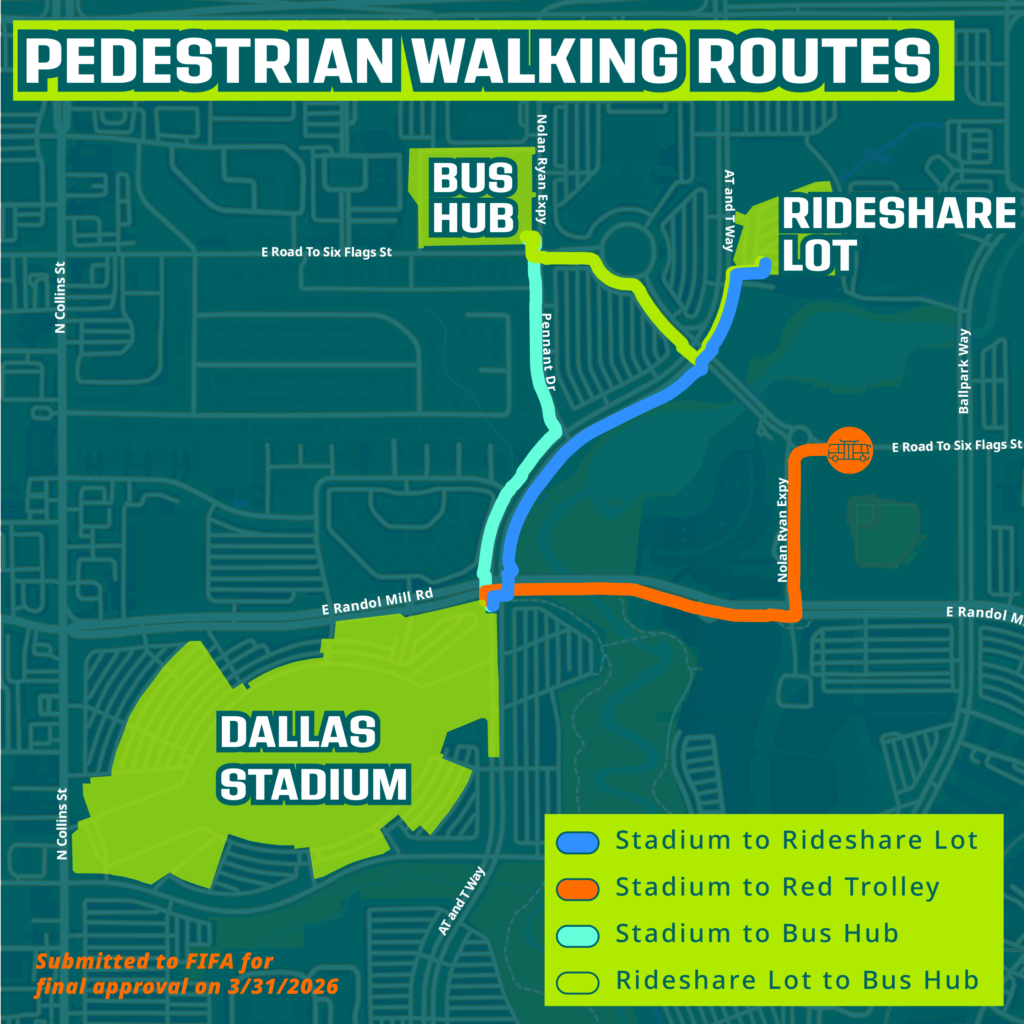
PEDESTRIAN WALKING ROUTES
This is a map of pedestrian walking routes from the Bus Hub, Rideshare Lot, and Red Trolley bus stop to Dallas Stadium. If arriving at the stadium by alternative forms of transportation, there are a few key connections to be aware of. The Bus Hub is where the Dynamic Charter Buses will drop off ticket holders coming from the Centreport Station. Those arriving by taxi or other Rideshare vehicles will be directed to the Rideshare Lot, which is the Parking for ESports Stadium Arlington, next to the Medal of Honor Museum. Pick-ups after the game will also be in this location for Rideshare and taxis. For those staying in Arlington, many hotels have access to the Red Trolley buses that circulate in the district. Drop-offs and pick-ups for the Trolley will be along E. Road to Six Flags, north of Choctaw Stadium. After the game, if the wait is too long at the Rideshare Lot, guests may walk over to the Bus Hub and return by Charter Bus to the TRE CentrePort Station, where they can continue their journey to downtown Dallas or downtown Fort Worth.
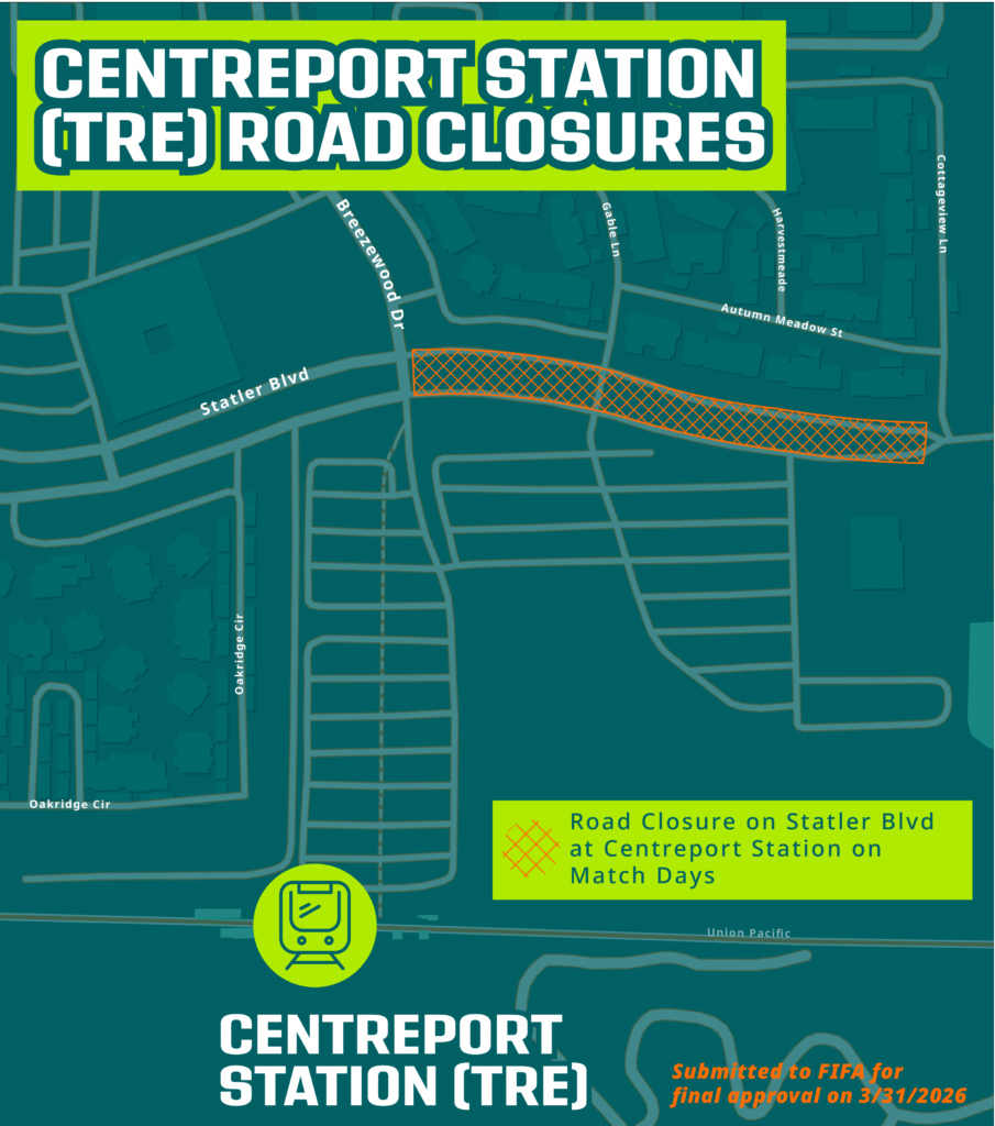
CentrePort Station (TRE) Road Closures
A map of the TRE CentrePort Station in Fort Worth, where TRE riders with match tickets will transfer to charter buses. A portion of Statler Boulevard from Breezewood Drive to Cottageview Lane will be closed to accommodate match day operations. Statler Boulevard is just north of the TRE CentrePort Station parking lot.